Burleson Estate Probate Map
Item

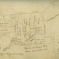
- Title
- Burleson Estate Probate Map
- Description
- This is the probate map created after the death of Edward Burleson in 1851. This map was found by Dr. Britt Bousman and his research students within the Hays County Records Building. The map was created on February 15, 1955 when Burleson's estate was divided among his heirs and creditors. Source: Center for Archaeological Studies, Texas State University.
- Contributor
- Center for Archaeological Studies, Texas State University
- Date
- February 15, 1855
- Digital image created in 2003
- Format
- JPG
- Language
- English
- Publisher
- Hays County, Texas.
- Rights
- This image is presented for research and educational purposes only, and may not be distributed or re-published without permission from the University Archives, Texas State University
- Subject
- San Marcos History
- Original Format
- Map
- Site pages
- The Mill Tract
- Media
 map3.JPG
Position: 2499 (16 views)